HMI, a Spaceborne High-Precision Greenhouse Gas Imager Developed by AIOFM, Returns First On-Orbit Data
安光所研制的星载高精度主要温室气体成像仪获取首批星上数据
Topics and contents
The High-precision Main Greenhouse gas Imaging instrument (HMI) aboard the Pujiang-4 satellite began imaging on September 27 and downlinked its first data. The instrument's developer, Xiong Wei's team at the Anhui Institute of Optics and Fine Mechanics (AIOFM), conducted a preliminary assessment showing that the payload's functions and performance meet design requirements. HMI uses an information modulation technique combining spatial imaging and spectral interferometry; in a 520 km orbit it acquires hyperspectral data with a 30 km swath, spatial resolution better than 400 m, and spectral resolution better than 0.125 nm. Based on the first data, the team preliminarily estimated the methane emission rate of the Bogatyr open-pit mine in Kazakhstan at about 27.52±1.70 tons per hour.
The original article gives HMI's swath width, spatial resolution and spectral resolution, and uses the first data to estimate methane emission rates at a mining site, showing the on-orbit performance of the combined spatial imaging and spectral interferometry scheme.
At 12:03 on September 20, Pujiang-4, a dedicated satellite for high-precision joint point-source detection of carbon dioxide and methane, was successfully launched. Its platform was designed for greenhouse gas point-source detection missions, and its sole payload is the spaceborne High-precision Main Greenhouse gas Imaging instrument (HMI), developed by the team of Researcher Xiong Wei at the Anhui Institute of Optics and Fine Mechanics, Hefei Institutes of Physical Science, Chinese Academy of Sciences. On September 27, the payload formally began imaging and completed the downlink of its first batch of on-orbit detection data. In a preliminary analysis conducted recently, the development team confirmed that the payload is functioning normally and that data quality meets the expected specifications.
The main task of the spaceborne High-precision Main Greenhouse gas Imaging instrument is to acquire hyperspectral- and high-spatial-resolution greenhouse gas observation data within its imaging area, retrieve atmospheric carbon dioxide and methane column concentration information, and provide satellite remote sensing data support for quantitative monitoring of greenhouse gas emissions from key sources such as global oil and gas fields, coal mines, coal-fired power plants and landfills.
Compared with similar payloads previously developed by the team, HMI innovatively employs an information modulation technique combining spatial imaging and spectral interferometry. From a 520 km orbit, it can simultaneously acquire hyperspectral data covering 30 km in the cross-track direction, with spatial resolution better than 400 meters and spectral resolution better than 0.125 nm. The satellite uses intelligent, autonomous multi-point observation mission planning on orbit, combined with large-angle agile side-slew and high-precision multi-magnification push-broom compensation, enabling timely, wide-swath, hyperspectral- and high-spatial-resolution detection of point sources worldwide.
The payload development team has now completed trial processing of the first batch of data products, and preliminary assessment shows that all payload functions and performance indicators meet the design requirements. Figure 2 shows the coverage and average spectral intensity map of the push-broom area over the Bogatyr open-pit mine in Kazakhstan obtained from the first batch of data; Figure 3 shows the spectral data cubes for the carbon dioxide and methane channels obtained after data processing; Figure 4 shows an enhanced plume reconstructed by fusing the methane-channel spectral retrieval results with dispersion simulation data, giving a preliminary estimate of the mine's methane emission rate of about 27.52±1.70 tons/hour.
Next, the Anhui Institute of Optics and Fine Mechanics team will continue on-orbit testing, calibration and validation of the payload in accordance with the satellite mission schedule, and will release a joint data application implementation plan for domestic research institutions. We look forward to working with researchers to jointly carry out quantitative greenhouse gas retrieval, emission source attribution, and source-sink analysis, helping China achieve its "dual carbon" goals and advance scientific research on global climate change.
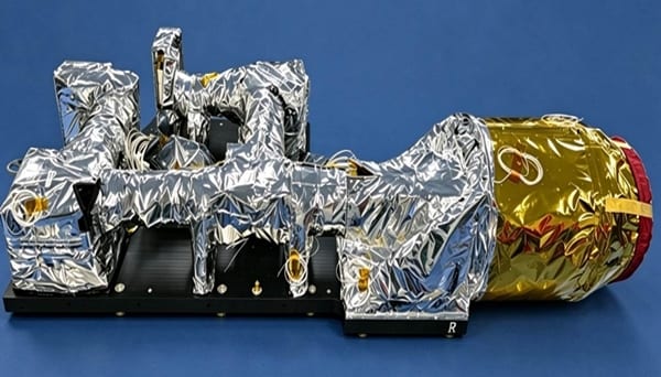
Figure1 Spaceborne High-precision Main Greenhouse gas Imaging instrument (HMI)
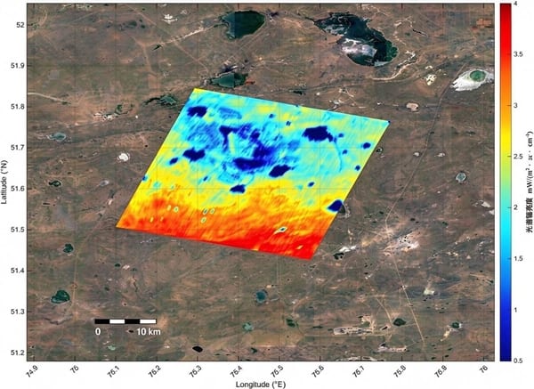
Figure2 HMI push-broom image of the Bogatyr open-pit mine (methane channel)
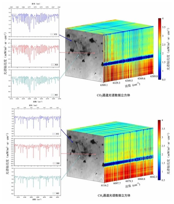
Figure3 HMI spectral data cube acquired over the Bogatyr open-pit mine area
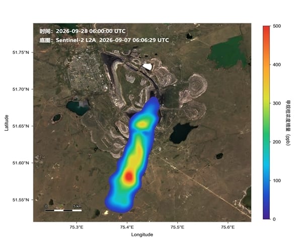
Figure4 Methane emission plume map of the Bogatyr open-pit mine (column concentration enhancement after subtracting the local background)
Source: Anhui Institute of Optics and Fine Mechanics (AIOFM) · Research Progress · aiofm.cas.cn