Guangzai Technology CO2 LiDAR Used to Validate High-Resolution Urban Carbon Emission Model
Topics and contents
Guangzai Technology, an incubated company of the Hangzhou Institute of Optics and Mechanics, collaborated with the University of Cambridge, Southeast University and others to publish a paper in Sustainable Cities and Society, proposing SCE-Model, a spatiotemporal carbon emission model optimized by machine learning and validated by LiDAR. The model output is highly consistent with coherent differential absorption LiDAR observations (R² = 0.79; ±5 ppm), enabling hourly, block-level carbon emission mapping.
Guangzai Technology, an incubated company of the Hangzhou Institute of Optics and Mechanics, has collaborated with the University of Cambridge, Southeast University, Nanjing University of Information Science and Technology, and the National Carbon Metrology Center (Fujian), among other renowned research institutions. Using the CO2 flux-detection LiDAR developed by Guangzai Technology's R&D team, the partners have developed a novel LiDAR-validated spatiotemporal carbon emission model framework, achieving significant progress in urban carbon emission estimation. The findings were published in Sustainable Cities and Society, a top-tier Category 1 journal in the built environment field, with an impact factor of 12.
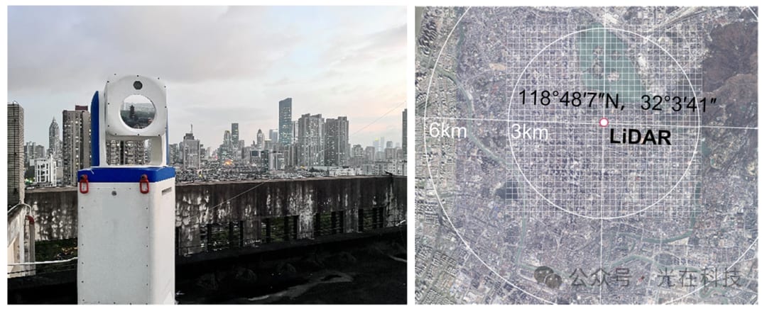
▲ Figure 1: Photo of the CO2 LiDAR developed by Guangzai Technology and its observation range
Accurate and actionable carbon emission accounting is critical to the sustainable transformation of high-density urban environments and to meeting global climate change mitigation goals. However, conventional methods lack both fine spatiotemporal resolution and reliable ground validation. To address this, the study proposes a machine-learning-optimized spatiotemporal carbon emission model (SCE-Model). The model output aligns closely with coherent differential absorption LiDAR observations (R² = 0.79; ±5 ppm), providing strong statistical support for its reliability at the neighborhood scale and confirming the critical role of LiDAR data in improving model accuracy and reliability.
The SCE-Model framework enables hourly, block-level carbon emission mapping, filling a key gap in current urban carbon monitoring. It offers a high-resolution carbon accounting method that supports the development of targeted emission reduction strategies in dense urban areas. The research provides a scientific basis for achieving urban carbon neutrality goals and advances the foundation for integrating anthropogenic emissions, urban green space, and neighborhood types into next-generation urban carbon management policies.
The SCE-Model framework comprises:
1) Multi-source data integration: combining heterogeneous urban datasets, including 3D building data, traffic condition data, population heat map data, and remote sensing data;
2) Urban carbon emission modeling: Four submodels are implemented, combining machine learning methods with physics-based emission models to capture nonlinear interactions;
3) LiDAR-based model validation: Near-surface LiDAR observations are used for high-resolution model validation;
4) Strategy development: Cluster analysis is applied to identify emission types and inform carbon reduction strategies for specific neighborhoods.
The results show that the integrated spatiotemporal analysis reveals how emission rhythms and spatial configurations jointly shape the carbon footprint at the neighborhood scale. Specifically, human metabolic activity dominates local emissions, a factor previously underappreciated in dense urban cores. Second, as the main anthropogenic emission sources, transportation and building emissions exhibit pronounced diurnal rhythms and spatial clustering, driving the formation of emission hotspots. Third, although urban green spaces and greenways concentrate some carbon sinks, they provide only modest offsets to these major anthropogenic emissions, highlighting a critical imbalance between carbon sinks and carbon sources.
As a replicable and validated model, SCE-Model offers a revolutionary new approach to high-resolution urban carbon accounting. It not only lays a scientific foundation for evidence-based carbon reduction planning and targeted climate action, but also provides a scalable pathway for dense cities worldwide to transition toward carbon neutrality.
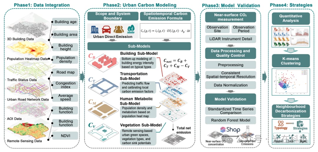
Figure 2 Spatiotemporal carbon emission model framework
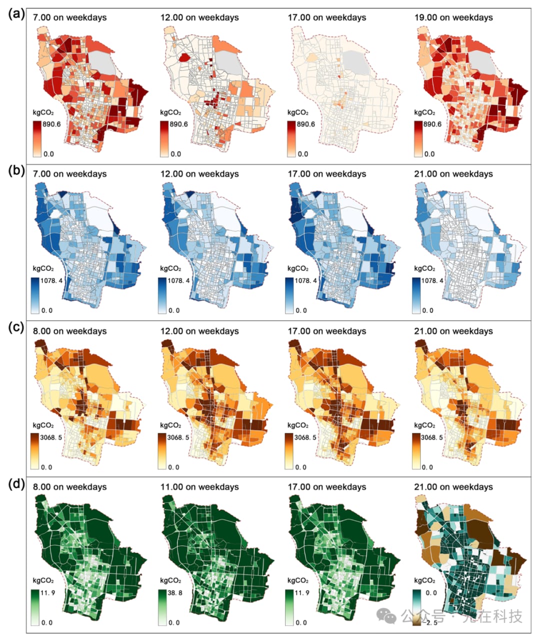
Figure 3 Dynamic distribution of source and sink spaces on weekdays.
(a) Buildings, (b) transportation, (c) human metabolism, (d) vegetation carbon sinks
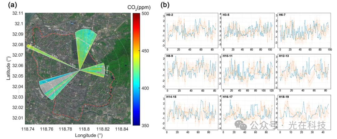
Figure 4 Comparison of near-surface CO2 concentration and simulated emissions. (a) Spatial distribution of near-surface CO2 observed by LiDAR within four directional sectors (unit: ppm). (b) Standardized time series of simulated net emissions (blue) and LiDAR-observed near-surface CO2 concentration (orange), with the shaded area indicating the ±1 standard deviation range of the simulated series.
Dr. Yixiang Chen, Dr. Zhen Zhang, Dr. Saifen Yu and Prof. Haiyun Xia of the R&D team contributed to the paper.
Paper: Yueyue Wu, Yi Zheng, Yixiang Chen, Xinbei Wang, Zhen Zhang, Saifen Yu, Haiyun Xia, ChengHe Guan*, "High-resolution carbon modeling in dense urban areas: LiDAR-validated spatiotemporal mapping for neighborhood decarbonization," Sustainable Cities and Society, 135, 106981, 2025.
Link:
https://doi.org/10.1016/j.scs.2025.106981.
Company Profile
Hangzhou Guangzai Technology Co., Ltd.
Guangzai Technology is a high-tech LiDAR enterprise integrating R&D and design, manufacturing, and technical services, and a leader in LiDAR manufacturing and solutions.
Guangzai Technology holds world-leading technologies in ultrafast femtosecond lasers, near-space wind field detection, single-photon quantum frequency conversion, and LiDAR with the highest resolution and longest range. It focuses on the R&D and manufacturing of intelligent LiDAR systems for ground-based, airborne, shipborne, and spaceborne platforms, building an integrated platform for multi-parameter observation and data fusion services covering the atmosphere, oceans, land, and targets, serving major national needs in defense, meteorology, emergency response, and the low-altitude economy.
The company's core technical team includes 10 PhDs, all with backgrounds in first-class disciplines in China. The team has focused on LiDAR R&D and production for 23 years, with multiple LiDAR technologies reaching world-leading levels. It has received honors including the 2014 First Prize for Military Science and Technology Progress, the 2017 Special Gold Award at the Geneva International Exhibition of Inventions, the 2021 Gold Award at the National Postdoctoral Innovation and Entrepreneurship Competition, the 2024 Second Prize for National Defense Science and Technology Progress, and the 2024 Gold Award of the
Guangzai Technology has developed LiDAR systems for a range of application scenarios, including multi-parameter atmospheric remote sensing LiDAR, multi-feature remote sensing LiDAR for "low, slow and small" targets, and 3D precision spectroscopic gas remote sensing LiDAR. Its products are mainly used in the low-altitude economy, emergency firefighting, carbon peaking and carbon neutrality and environmental protection, and battlefield environment awareness and forecasting.
Source: Hangzhou Institute of Optics and Fine Mechanics · Industry News · hiom.ac.cn